


وصف لـ GPS Logger
BasicAirData GPS Logger is a simple App to record your position and your path.
It's a basic and lightweight GPS tracker focused on accuracy, with an eye to power saving.
It works offline (without internet connection), it has NO integrated maps.
This app is very accurate in determining your altitude: enable EGM96 automatic altitude correction on settings!
You can record all your trips, view them with any installed external viewer, directly from the in-app tracklist, and share them in KML, GPX, and TXT format in many ways.
The app is 100% Free and Open Source.
GETTING STARTED GUIDE:
http://www.basicairdata.eu/projects/android/android-gps-logger/getting-started-guide-for-gps-logger/
IT FEATURES:
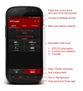
- A modern UI, with a low consumption dark theme and a tabbed interface
- Offline recording (the app has no integrated maps)
- Foreground & Background Recording (On Android 6+ please turn off all battery monitoring and optimizations for this app!!)
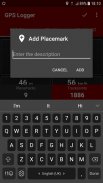
- Placemarks creation also meanwhile recording
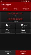
- Visualization of GPS information
- Manual Altitude Correction (adding an overall offset)
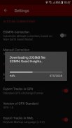
- Automatic Altitude Correction, based on NGA EGM96 Earth Geoid Model (Enable it on Settings!!!). On Android 4 this feature can only be enabled manually by following this simple tutorial: https://www.basicairdata.eu/projects/android/android-gps-logger/application-note-gpslogger/manual-setup-of-the-egm-altitude-correction-for-basic-air-data-gps-logger/
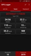
- Real time track statistics
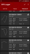
- In-app tracklist showing the list of recorded tracks
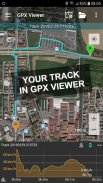
- Visualization of your tracks using any installed KML/GPX viewer, directly from the Tracklist
- Track exportation, in the /GPSLogger folder of your device, in KML, GPX, and TXT
- Track sharing, in KML, GPX, and TXT format, via E-mail, Dropbox, Google Drive, FTP, ...
- Uses Metric, Imperial, or Nautical units
USE IT TO:
☆ Keep track of your trips
☆ Make accurate static and dynamic measurements
☆ Add your placemarks
☆ Remember the best places you've seen
☆ GeoTag your photos
☆ Share your tracks with your friends
☆ Collaborate to OpenStreetMap map editing
☆ ...
LANGUAGES:
The translation of this app is based on users contribution. Everyone can freely help in translations using Crowdin (https://crowdin.com/project/gpslogger).
F.A.Q:
Problems with this app? Read the most frequently asked question! (https://github.com/BasicAirData/GPSLogger/blob/master/readme.md#frequently-asked-questions).
ADDITIONAL INFORMATION:
- Copyright (C) 2016 BasicAirData - http://www.basicairdata.eu
- For additional information please see http://www.basicairdata.eu/projects/android/android-gps-logger/
- This program is free software: you can redistribute it and/or modify it under the terms of the GNU General Public License as published by the Free Software Foundation, either version 3 of the License, or (at your option) any later version. See the GNU General Public License for more details: http://www.gnu.org/licenses.
- You can view and download the source code of this app on GitHub: https://github.com/BasicAirData/GPSLogger
- When The EGM96 Automatic Correction is enabled for the first time into the Setting Screen, the geoid Height file is downloaded from the NGA/NASA website. (File size: 2 MB).
BasicAirData GPS Logger هو تطبيق بسيط لتسجيل موقعك ومسارك.
إنه جهاز تعقب GPS أساسي وخفيف الوزن يركز على الدقة ، مع توفير الطاقة.
يعمل دون اتصال بالإنترنت (بدون اتصال بالإنترنت) ، ولا يحتوي على خرائط متكاملة.
هذا التطبيق دقيق للغاية في تحديد الارتفاع الخاص بك: تمكين تصحيح الارتفاع التلقائي EGM96 على الإعدادات!
يمكنك تسجيل جميع الرحلات الخاصة بك ، وعرضها مع أي عارض خارجي مثبت ، مباشرة من قائمة التتبع داخل التطبيق ، ومشاركتها بتنسيق KML و GPX و TXT بعدة طرق.
التطبيق مجاني 100 ٪ ومفتوح المصدر.
دليل البداية:
http://www.basicairdata.eu/projects/android/android-gps-logger/getting-started-guide-for-gps-logger/
ميزات تكنولوجيا المعلومات:
- واجهة مستخدم حديثة ، ذات سمة مظلمة منخفضة الاستهلاك وواجهة مبوبة
- التسجيل في وضع عدم الاتصال (لا يحتوي التطبيق على خرائط متكاملة)
- المقدمة والخلفية تسجيل (على أندرويد 6+ + يرجى إيقاف جميع مراقبة البطارية والتحسينات لهذا التطبيق!)
- إنشاء العلامات الموضعية في الوقت نفسه تسجيل
- التصور من المعلومات GPS
- تصحيح الارتفاع اليدوي (إضافة إزاحة شاملة)
- تصحيح الارتفاع التلقائي ، استنادًا إلى NGA EGM96 Earth Geoid Model (تمكينه على الإعدادات !!!). في Android 4 ، لا يمكن تمكين هذه الميزة يدويًا إلا باتباع هذا البرنامج التعليمي البسيط: https://www.basicairdata.eu/projects/android/android-gps-logger/application-note-gpslogger/manual-setup-of-the- الجمعية العمومية غير العادية على ارتفاع تصحيح المتاحة للهواء، نظام تحديد المواقع البيانات الأساسية، ومسجل /
- في الوقت الحقيقي تتبع الإحصاءات
- قائمة المسارات داخل التطبيق تظهر قائمة المسارات المسجلة
- تصور مساراتك باستخدام أي عارض KML / GPX مثبت ، مباشرة من قائمة المسارات
- تتبع التصدير ، في مجلد / GPSLogger بجهازك ، في KML و GPX و TXT
- تتبع المشاركة ، بتنسيق KML و GPX و TXT ، عبر البريد الإلكتروني و Dropbox و Google Drive و FTP و ...
- يستخدم وحدات متري أو إمبراطوري أو بحري
استخدمها لـ:
☆ تتبع الرحلات الخاصة بك
☆ قم بإجراء قياسات ثابتة وديناميكية دقيقة
☆ أضف العلامات الموضعية الخاصة بك
☆ تذكر أفضل الأماكن التي رأيتها
o GeoTag صورك
☆ مشاركة المسارات الخاصة بك مع أصدقائك
to التعاون لتحرير خريطة خريطة الشارع المفتوح
☆ ...
اللغات:
تعتمد ترجمة هذا التطبيق على مساهمة المستخدمين. يمكن للجميع المساعدة بحرية في الترجمات باستخدام Crowdin (https://crowdin.com/project/gpslogger).
التعليمات:
مشاكل مع هذا التطبيق؟ قراءة السؤال الأكثر شيوعا! (https://github.com/BasicAirData/GPSLogger/blob/master/readme.md#frequently-asked-questions).
معلومة اضافية:
- حقوق الطبع والنشر (C) 2016 BasicAirData - http://www.basicairdata.eu
- للحصول على معلومات إضافية ، يرجى مراجعة http://www.basicairdata.eu/projects/android/android-gps-logger/
- هذا البرنامج عبارة عن برنامج مجاني: يمكنك إعادة توزيعه و / أو تعديله وفقًا لشروط رخصة جنو العمومية على النحو المنشور من قبل مؤسسة البرمجيات الحرة ، إما الإصدار 3 من الترخيص ، أو (حسب اختيارك) أي إصدار لاحق. انظر رخصة جنو العمومية العامة لمزيد من التفاصيل: http://www.gnu.org/licenses.
- يمكنك عرض وتنزيل الكود المصدري لهذا التطبيق على جيثب: https://github.com/BasicAirData/GPSLogger
- عند تمكين EGM96 Automatic Correction لأول مرة في شاشة الإعداد ، يتم تنزيل ملف Geoid Height من موقع NGA / NASA. (حجم الملف: 2 ميغابايت).
GPS Logger - إصدار 3.2.2
(29-01-2024)
GPS Logger - معلومات APK
نُسخة APK: 3.2.2الحزمة: eu.basicairdata.graziano.gpsloggerتطبيقات من الفئة نفسها
قد يعجبك أيضًا...


